Ground Control Station Software for Unmanned Vehicles
Agno Horizon GCS is AGNOBİL's ground control station (GCS) software, developed to prepare an unmanned vehicle before flight, monitor and manage it during the mission, and analyze it after the flight. It works with the same operating logic on desktop, tablet and phone, and communicates with vehicles that use the MAVLink protocol. The public version is free and intended for civil use; the Military Mode for defense and security organizations is licensed separately.
Civil Distribution and Military Mode
Civil Distribution
Agno Horizon GCS, published on Google Play, the App Store and the download page, is intended for civil use and can be used free of charge by everyone. It includes the full set of mission planning, telemetry, video, vehicle setup and analysis tools.
Military mode features do not work in this version.
Military Mode
A separately licensed level for defense and security organizations. In addition to all capabilities of the civil version, it enables the military mission modules below. The license is granted per organization and platform; additional custom arrangements are made on request.
Capabilities Offered in Military Mode
The modules offered under the military mode license are configured according to the platform, mission profile and organization's needs.
Autonomous Docking
Planning and management of precision approach, alignment and docking missions to a station or moving platform.
Kamikaze Dive
Planning of the terminal dive phase after target lock, with operator confirmation and mission abort control.
Multi-Mission Management
Simultaneous mission planning, task assignment and single-screen tracking of multiple vehicles.
Target Detection and Tracking
Vision-based target detection, target lock and switching the vehicle to automatic tracking mode.
Swarm Movement
Vehicles moving in formation, task sharing within the swarm and coordinated maneuvers.
Encrypted Communication
End-to-end encryption on command-and-control and telemetry channels, and protection against unauthorized access.
GNSS-Denied Environment Support
Mission continuity with visual and inertial navigation support in case of GNSS jamming or spoofing.
Electronic Warfare Resilience
Integration with frequency-hopping data links and defined autonomous behaviors in link-loss scenarios.
Tactical Map Layers
MGRS / UTM coordinate systems, tactical symbol layers and offline military map support.
Payload Control
Mission plan-driven control of payloads such as EO/IR cameras, gimbals and payload release.
Command and Control Integration
Data sharing with the WAIA multi-domain command-and-control architecture and higher-level command systems.
Authorization and Mission Logging
Role-based operator permissions, mission logs and an audit trail for later review.
Military mode is provided only to authorized organizations, under license and with the necessary permits. Module scope and technical details are shared on request.
What Is GCS Software?
GCS (Ground Control Station) software is the main interface between the unmanned vehicle and the operator: missions are planned and uploaded to the vehicle, the flight is monitored live and commands are issued when needed.
Agno Horizon GCS brings all these processes together in a single application. With the same software, the operator prepares the vehicle, plans the mission, manages the flight and reviews post-flight logs. The simplified interface is designed for fast use in the field; technical settings such as calibration, parameters and firmware operations are offered under advanced mode.
What Does Agno Horizon GCS Do?
Flight Screen
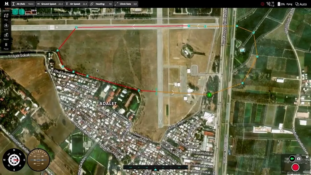
Vehicle position and mission route on the map; relative altitude, ground speed, airspeed, heading and climb rate on the top telemetry bar; attitude and compass indicators. Takeoff, mission start, return and landing commands are given with slide-to-confirm.
Mission Planning
Waypoint-based route creation on the map; area survey, corridor scan and structure scan mission templates; geofence and rally point definitions. Plans can be saved as files and uploaded to the vehicle.
Vehicle Setup
Sensor and radio calibration, flight mode assignments, power and safety (failsafe) settings, and a full parameter editor. Firmware upload is offered under advanced mode.
Analysis Tools
Downloading onboard flight logs, MAVLink message inspector and console, and geotagging images with the flight log (GeoTag).
Video Streaming
Displaying and recording the video coming from the vehicle camera over RTSP or UDP on the flight screen.
Connection and Maps
Serial port, UDP and TCP connection profiles; different map providers and an offline map cache for use in the field without internet.
Desktop, Android and iOS Versions
Desktop (Windows · Linux)
For command center and portable ground control station computers. Mission planning on a large screen, video and telemetry tracking with multiple windows. Used together with ground control station hardware.
Android
A touch-friendly interface for tablets and handheld ground control devices. Published on Google Play.
iOS
Fast mission tracking and control in the field on iPad and iPhone. Published on the App Store.
The versions published in the stores and on the download page are the civil distribution; military mode is not enabled in these versions. See the Agno Horizon download page for all versions and the privacy policy for data processing principles.
SITL Flight Test
The video shows a mission flight performed with Agno Horizon GCS in a software-in-the-loop (SITL) simulation environment: planning the route, starting the mission and tracking telemetry throughout the flight.
The simulation test was performed to validate the mission flow and ground software behavior without using a real vehicle.
Agno Horizon GCS Features
| Platforms | Windows, Linux, Android, iOS |
|---|---|
| Communication Protocol | MAVLink |
| Connection Types | Serial port, UDP, TCP |
| Mission Planning | Waypoint route, area/corridor/structure survey, geofence, rally points, saving and loading plan files |
| Flight Monitoring | Vehicle and route on the map, telemetry bar, attitude and compass indicators, slide-to-confirm commands |
| Video | RTSP / UDP video streaming, recording |
| Vehicle Setup | Sensor and radio calibration, flight modes, safety settings, parameter editor |
| Analysis | Log download, MAVLink inspector and console, GeoTag |
| Map | Different map providers, offline map cache |
| Input Devices | Touch, mouse/keyboard, joystick and gamepad |
Questions and Answers
Is Agno Horizon GCS free?
Yes. The version published on Google Play, the App Store and the download page is intended for civil use and can be used free of charge by everyone.
What is Military Mode and how do I get it?
Military Mode is a separately licensed level for defense and security organizations that enables modules such as autonomous docking, kamikaze dive, multi-mission management, target detection, swarm movement and encrypted communication. It does not work in the public version; you can apply for a license via the contact form.
What is GCS software?
GCS (Ground Control Station) software is the ground control station application used to plan an unmanned vehicle's mission, upload it to the vehicle, monitor the flight live and issue commands.
Which operating systems does Agno Horizon GCS run on?
It runs on Windows, Linux, Android and iOS. The Android version is published on Google Play and the iOS version on the App Store; desktop versions are available from the Agno Horizon download page.
Which vehicles is it compatible with?
Agno Horizon GCS communicates with unmanned vehicles that use the MAVLink protocol. It is designed to be used together with the Agno Horizon flight control board and Horizon Core firmware.
Can it be used without internet?
Yes. Maps of the mission area can be cached in advance in the offline map cache; the connection to the vehicle is established locally over serial port, UDP or TCP.
Is video streaming supported?
Yes. Video from the vehicle camera via RTSP or UDP is displayed on the flight screen and can be recorded.
Related Technologies
Ground Control Stations
Handheld, portable and in-vehicle ground control computers.
Explore →Autopilot & Firmware
Horizon Core: control algorithms, flight modes and embedded software.
Explore →Flight Control Board
The vehicle's real-time control hardware with domestic PCB design and sensor integration.
Explore →Communication & Command Control
Data link, network architecture and multi-domain command and control.
Explore →Contact Us for a Military Mode License
Share your organization, platform and the military mode modules you need, and we will evaluate your license and custom arrangement requests. No application is needed for the civil version.